Mission
To facilitate trade for the businesses and communities of northeastern Oregon.
Vision
To serve northeastern Oregon as the premier transportation hub, providing opportunities for industry.
Port Facilities
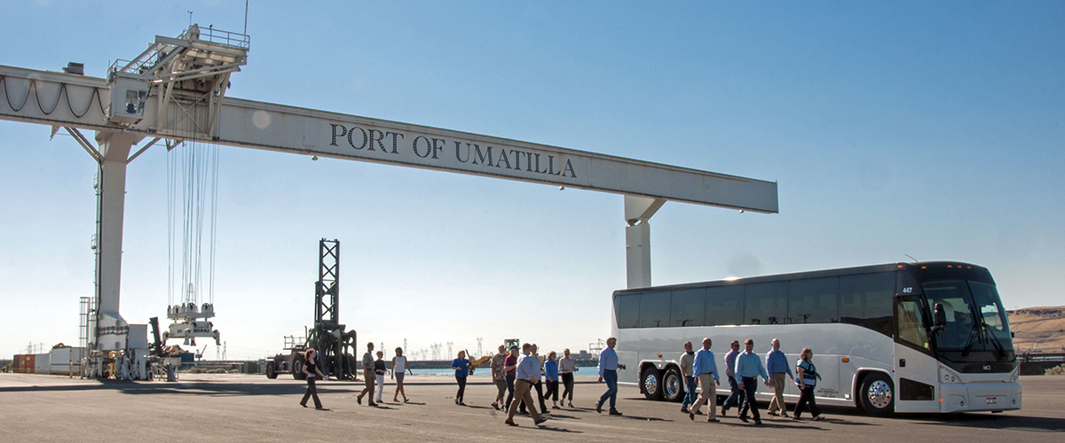
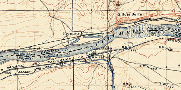
Located on the Columbia River, the Port of Umatilla is “Oregon’s Inland Port.” The Port is situated in the center of the Pacific Northwest and serves as an excellent gateway for distribution to Western U.S., the Upper Midwest and East, as well as allowing efficient connections throughout the world. The Port’s 3,200 square mile jurisdiction encompasses 12 municipalities. Two Interstate highways, a major railroad switch yard, and a new modern full-service Columbia River maritime facility equipped to handle containers, grain, petroleum, and project cargo serve the intermodal transportation needs of the Port’s shippers.
- Bulk and Breakbulk
- McNary Elevator Dock — A 10-car surface rail track connects the dock to the Union Pacific Railroad. At the rear of this Port of Umatilla dock is a grain elevator with capacity for three million bushels of grain. The McNary Elevator Dock in the Port of Umatilla has berthing distance of 152.4 meters (500 feet) with alongside depth of 5.8 meters (19 feet).
- Fuel/Liquid
- Tidewater Terminal Company owns and operates the Port of Umatilla Dock to ship and receive petroleum products and liquid fertilizer and to fuel vessels. Two pipelines connect the wharf to 14 storage tanks with total capacity for 140 thousand barrels of petroleum products and to one tank owned by the Union Pacific Railroad with capacity for 42 thousand barrels. A third pipeline extends to five storage tanks with total capacity for about 95 thousand US barrels of liquid fertilizer. The pier also has a fueling pipeline. The Port of Umatilla Dock has berthing distance of 91.4 meters (300 feet) with alongside depth of 5.8 meters (19 feet).
History
- Before white settlers entered the area, the Walla Walla and Umatilla people shared the resources of the Big River (the Columbia), and the Cayuse lived in the Blue Mountains. The regional river system not only supported the daily life of the tribes but also linked them to other tribes for trade, marriage, politics, and conflict. In 1805, the Lewis and Clark expedition noted that the tribes lived along the Columbia, Yakima, Walla Walla, and Snake rivers. Many people lived on the Columbia River throughout the year due to the abundant fisheries. Some went to the mountains to hunt and gather food, medicines, and other natural resources. In 1855, tribal leaders of the Walla Walla, Cayuse, and Umatilla tribes were ceded more than six million acres to the United States through a treaty. The tribes formed a single tribal government in 1949. Today, the Confederated Tribes of the Umatilla Indian Reservation is a federally-recognized tribe that contains the tribes that traditionally lived in the Columbia River Plateau region. With a population of about 2800 tribal members, about half of the people live on the reservation. People from other tribes also live on the reservation including Yakima, Nez Perce, and Tenino. The reservation occupies about 70 hectares, and the tribes share a government structure. Much of the reservation land is owned by non-Indians today. Tribal leadership led to the reintroduction of salmon to the Umatilla River in the 1980’s. In 1995, the Wildhorse Resort & Casino was opened resulting in a dramatic reduction in unemployment for the tribes.
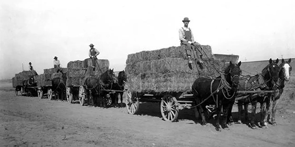
- In 1851, the first US post office was established for the Port of Umatilla. Incorporated in 1864 as Umatilla Landing, but the citizens dis-incorporated the town two years later because municipal government was an unacceptable burden. In 1906, it was re-incorporated as the City of Umatilla. The Port of Umatilla was an important Columbia River trade and distribution center during the gold rush days of the 1860’s and 1870’s. In the 1880’s competition from the Oregon Railway and Navigation Company led to a decline.One of the State’s 23 port districts, the Port of Umatilla was created in 1940 to bring water-borne commerce to Umatilla County. In the mid-20th Century, the Port of Umatilla acquired industrial property when the federal government declared surplus land at the McNary Dam project. In 1960, the Port of Umatilla opened a barge dock. In 1968, the Port of Umatilla opened a recreational boat marina, now owned by the city of Umatilla.
- Over the years, the Port of Umatilla has been involved in economic development across the port district. In 1941, the Umatilla Chemical Depot opened as the United States prepared to go to war. The depot was used then to store military items. In 1962, the depot was used to store chemical weapons. The last barrel of HD mustard agent was destroyed in 2011. In 1968, the city was moved to higher ground in anticipation of flooding with the completion the new John Day Lock and Dam. The 130-acre area that did not flood is known today as Old Town, and it is listed on the National Register of Historic Places.
- Archaeologists have found evidence of pre-Columbian inhabitants in the Port of Umatilla area, and an ancient burial ground is protected. The first archaeological dig was done in 1965 by the University of Oregon. The Mid Columbia Archaeological Society conducted another dig in 1970, and the Washington Archaeological Research Center explored the site in 1979. The Umatilla archaeological site is the biggest of its kind in Oregon.
- In the 1990s, the Port of Umatilla worked with the City of Hermiston to establish the Regional Water System that includes a Columbia River pumping Station, pipelines, and a treatment plant. The regional water system supports the City, power plants, and food processing industries.